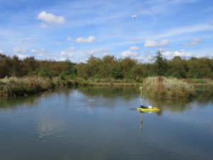
WSSI’s remote controlled hydrographic survey vessel
The lakes, ponds, and rivers in our landscape are valued for their aesthetics, water quality benefits, and recreation opportunities. For local communities, HOAs, developers, and other stakeholders, the function of these waterbodies can be diminished over time by the accumulation of sediment. In addition to the loss of function, there can also be regulatory implications related to the volume of the facility (resulting from either the loss of design volume (primarily in SWM ponds) or the total volume, which is a parameter used to determine whether the facility is large enough to be regulated by the state).
Since 2001, WSSI has provided bathymetric surveys for a wide range of projects, from small “farm” ponds to larger lakes and reservoirs, stormwater management ponds, and navigable rivers. These surveys have been used to:
- Analyze the accumulation of sediment over time, allowing managers to plan and budget for dredging operations.
- Determine pond and sediment depth to calculate the quantity of sediment for permitting purposes, as well as to aid in planning for disposal (a major cost).
- Determine the volume of the impoundment for assessing whether the facility is large enough to be regulated by the state (Department of Conservation and Recreation).
- Document the effectiveness of erosion and sediment control measures on active construction sites located upstream of the facility, as demonstrated by the amount of accumulated sediment.
- Enable community planners to pinpoint areas of significant sedimentation for maintenance dredging prior to a loss in function and/or the development of adverse aesthetic conditions.
- Display changes in boat slip and channel depths for marina owners and managers.
- Provide data required for permits necessary for pier construction and other riparian issues.
In some localities, bathymetric surveys are required to demonstrate regulatory compliance. In Fairfax County, pre and post-construction bathymetric surveys are required for land disturbing activities on parcels located upstream from lakes and ponds: “Impacts in the form of siltation to downstream properties, especially natural resources, may result in significant liabilities to a developer involving litigation with the affected parties that may take a substantial amount of time and expense to resolve”.
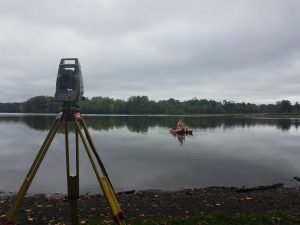
WSSI surveyor collecting sediment depth data
WSSI conducts all bathymetric surveys in full compliance with U.S. Army Corps of Engineers (COE) guidelines and regulations. Our 16 years of bathymetric survey experience and state of the art equipment enable our surveyors to tailor the methods and approach to meet the specific needs of every project. Our Odom Echotrac CVM Mobile Hydrographic System and/or HydroLite Echosounder can be mounted on any of the vessels owned by WSSI to collect bathymetric data in deeper waters. WSSI has also recently acquired the Seafloor HyDrone-G2-RCV remote controlled hydrographic survey vessel, providing additional flexibility for bathymetric data collection. In shallower water, where sonar technology is not practical, we employ a sounding pole method in accordance with COE regulatory requirements. Where conditions allow (shallow water and soft sediments), we can estimate the depth of the accumulated sediment to aid in estimating the volume. This method is employed when as-built plans for the impoundment are not available.
Reach out to one of our contacts below to discuss your project or to learn more about our bathymetric survey capabilities.